Severe Storms Sweep Philadelphia Region as Warnings Persist
A tornado warning in Burlington County, New Jersey, was canceled Tuesday night, but severe thunderstorm warnings remained in parts of the Delaware Valley.
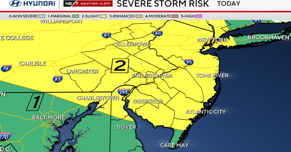
Tuesday Night Warnings
A tornado warning issued for Burlington County, New Jersey, was canceled Tuesday night as severe storms moved through the Philadelphia region, CBS News reported.
A severe thunderstorm watch covering the Philadelphia region expired, but CBS News said some severe thunderstorm warnings remained in effect for parts of the Delaware Valley, the area around Philadelphia that spans southeastern Pennsylvania and southern New Jersey.
The storms carried heavy rainfall, gusty winds and frequent lightning. CBS News said damaging winds, hail and an isolated tornado were also possible.
Watch Area and Timing
WFMZ-TV, a station serving eastern Pennsylvania and western New Jersey, reported that a severe thunderstorm watch had been issued for its entire coverage area and was in effect through midnight.
Meteorologist Dan Skeldon wrote that damaging wind gusts and large hail were the two main concerns, with an isolated tornado or two possible but far less likely. He noted that any thunderstorm, severe or not, can bring frequent lightning and heavy downpours, and that a slow-moving storm in the high humidity could drop an inch or two of rain and cause localized flooding.
Storms began developing around 4 p.m. across parts of eastern Pennsylvania and northern New Jersey, according to WFMZ. The station said the most likely window for severe storms ran roughly from 5 p.m. through 11 p.m., moving from northwest to southeast.
Watches Versus Warnings
WFMZ explained the difference between the two alerts. A severe thunderstorm watch does not guarantee severe weather; it means conditions could support gusty storms.
A severe thunderstorm warning is issued when storms have developed and are imminent at a specific location.
The Days Ahead
CBS News said heat and storm chances would continue Wednesday and Thursday, with storms forming each day and moving northwest to southeast around a large ridge of high pressure to the south.
Conditions will support severe storms at some point each day, mainly through the afternoon and evening, the station reported. By Thursday, a strong cold front is expected to cross the area and push the severe threat southward, though the threat area still includes Philadelphia and points south.
CBS News forecast a high of 90 and a low of 72 for Thursday, with a weather alert for storms and heat. The unsettled pattern is expected to break down by Friday, leaving highs near 80 degrees, partly cloudy skies and lower humidity for the first weekend of September.
More from Donator TRENDS

IMD alerts 19 states for heavy rain and thunderstorms
The India Meteorological Department has warned of heavy rain and squally winds across 19 states, as flooding hits parts of Uttar Pradesh.
Weather
Airlink cancels stadium flyby as cut-off low approaches
The South African Weather Service has warned of heavy rain, damaging winds, rough seas and a sharp temperature drop from Thursday.
Weather
Severe Storms Set to Sweep Southern Ontario Wednesday
Forecasters warn of damaging winds, large hail and an isolated tornado risk as a cold front pushes through the Greater Toronto Area.
Weather
Morning Storms and Cooler Air Follow Wisconsin Heat
Forecasters in Wausau and Green Bay describe scattered thunderstorms, a drop in temperatures and rain totals too light to ease drought.
Weather
Tropical Storm Edouard Closes In on Texas and Louisiana
Forecasters warned of heavy rain, flash flooding and a possible storm surge as Edouard moved toward the northwest Gulf coast on Tuesday.
Weather
India's August rain falls 16% short as El Niño builds
India Meteorological Department data show the seasonal monsoon deficit widening to 14%, with Kerala hit by deadly floods despite a dry season overall.
Weather